Garrads Road
Conservation Area Appraisal No.43
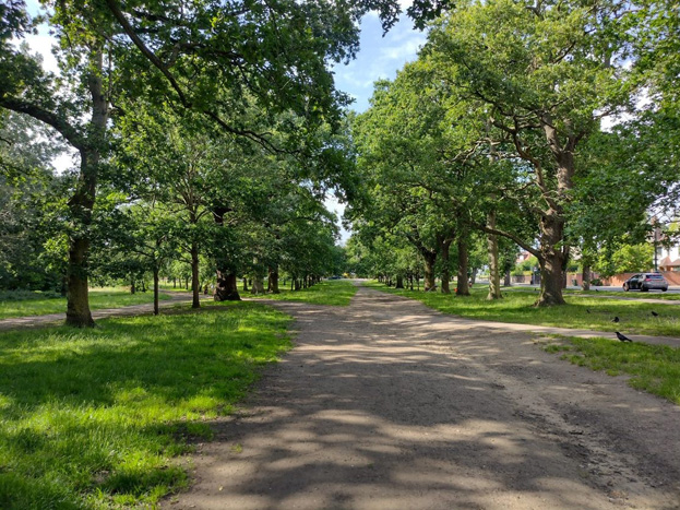
Fig. 1: Garrads Road Conservation Area
Contents
Part 1: Introduction
Outline of Purpose
The principle aims of Conservation Area Appraisals are to:
- describe the architectural and historic character and appearance of the area, which will assist applicants in making successful planning applications, and decision makers in assessing planning applications
- raise public interest and awareness of the special character of their area
- identify the positive features which should be conserved, as well as the negative features which indicate scope for future enhancement
It is important to note that no Appraisal can be completely comprehensive, and the omission of a particular building, feature, or open space should not be taken to imply that it is of no interest.
This document has been produced using the guidance set out by Historic England in the 2019 publication ‘Conservation Area Appraisal, Designation and Management: Historic England Advice Note 1 (Second Edition)’.
This document will be a material consideration when assessing planning applications.
What is a Conservation Area?
The statutory definition of a conservation area is an ‘area of special architectural or historic interest, the character or appearance of which it is desirable to preserve or enhance’. The power to designate conservation areas is given to local authorities through the Planning (Listed Buildings and Conservations Areas) Act, 1990 (Sections 69 to 78).
Once designated, proposals within a conservation area become subject to local conservation policies set out in the Council's Local Plan and national policy outlined in the National Planning Policy Framework.
Our overarching duty which is set out in the Act is to preserve and/or enhance the historic or architectural character or appearance of the conservation area.
Designation and Adoption Dates
Garrads Road Conservation Area was originally designated on the 22nd October 1969 as part of a larger Conservation Area now known as Streatham Park and Garrads Road Conservation Area. The Conservation Area was entirely within the boundaries of the Borough of Lambeth
In 1996 the Borough boundaries changed, with the entirety of Tooting Bec Common becoming part of Wandsworth, resulting in the Conservation Area straddling the boundary with Lambeth.
The present Garrads Road Conservation Area remains contiguous with the Streatham Park and Garrads Road Conservation Area in Lambeth.
Following approval by the Executive at its meeting on the 21st November 2022, it was agreed to carry out a public consultation on this Appraisal between the 10th February and 24th March 2023.
This Appraisal was adopted on the 31st August 2023.
Other Planning Designations
This section of Tooting Common is also:
- Metropolitan Open Land
- Registered Common Land
- Site of Importance for Nature Conservation
- On the Wandsworth Local Heritage List
- Tooting Common Archaeological Priority Area
The Tooting Common Management and Maintenance Plan was published in 2015.
It should be seen as a continuous heritage asset with the Lambeth Borough Streatham Park and Garrad’s Road Conservation Area, of which it was once part of.
The Greater London Archaeology Advisory Service (GLAAS) completed its review of Wandsworth Borough’s Archaeological Priority Areas (APAs) in 2017. Tooting Common is identified as a Tier 3 Archaeological Priority Area as it represents a good survival of a distinctive historic rural landscape. The full review can be found on the Historic England website as well as further information and guidance on Archaeological Priority Areas.
Heritage Assets
There are no separate heritage assets (such as listed buildings) contained within the area.
Map of Conservation Area
Statement of Special Interest
Summary of special architectural and historic interest of the Conservation Area:
This section of Tooting Common is a historic common which can be used to understand how changes in land use and law have influenced how land is used. The remains of an historic avenue of oak trees planted at the eastern edge to commemorate a visit by Queen Elizabeth I emphasise the historic nature of the land. Surrounded by the leafy suburban expansion of Streatham, the common serves as an important aspect of their setting. The common area is an important element of open space which contributes to the special interest of the neighbouring designated heritage asset Streatham and Garrads Road Conservation Area, which is located within the London Borough of Lambeth
Historic Development
The common rights which established the Tooting Common we see today would have been established by the Statutes of Merton (1235). This gave landowners, either lords of the manor or monasteries, power to enclose areas of common land provided that they also left some land that was free for tenants to use.
Over time substantial areas of the best quality agricultural land was enclosed leaving smaller and lower quality areas of land left where people could exercise their common rights.
Historically there were two Commons: Tooting Bec Common, and the much smaller Tooting Graveney Common. Tooting Bec Common’s name derives from Tooting Bec Manor, which was owned by Tooting Bec Priory who were associated with the Bec Abbey in Normandy. The Priory was dissolved in1315 and the land was granted to Eton College in 1440.
By 1873 the Metropolitan Board of Works had acquired full manorial rights over Tooting Bec Common and so it was protected from further enclosure. From this point onwards the Common was developed as a public space for recreation. Management of the Common passed to London County Council in 1889 and Wandsworth Council in 1970.
In the years following municipalisation in the late nineteenth century the character of the Common changed after the laying of paths, levelling of ground, and the introduction of leisure venues.
The part of the Common included in this Appraisal was largely untouched by any major clearance of trees and remains one of the more predominantly wooded areas of the Common.
Key Changes
Late 16th Century
An avenue of oak trees was planted along what is now Dr Johnson Avenue to commemorate a visit to Tooting by Queen Elizabeth I. A double line of elm trees was also planted along the southern boundary of the Common during this period, possibly by the Duke of Bedford.
Late 17th Century
An avenue of oak trees was planted along the route of Garrads Road.
1729
An additional line of trees was planted between Dr Johnson Avenue and Garrads Road by Ralph Thrale of Streatham Park.
1750s-80s
Samuel Johnson was connected with the area through his friendship with the Thrale family who lived nearby in Streatham Park.
Early 19th century
Bedford Hill thoroughfare was constructed.
1861
The London, Brighton and South Coast line was built, cutting north-south and breaking off the Garrads Road area of the Common from the rest.
1873-1875
The Metropolitan Board of Works acquired both Commons.
1906
Tooting Bec Lido and Arts and Crafts café were constructed with subsequent later 20th century enhancements.
1987
The Great Storm caused the loss of a large number of trees within the Common.
1996
The boundary of the administrative area of the London Borough of Wandsworth was changed to include the whole of Tooting Common.
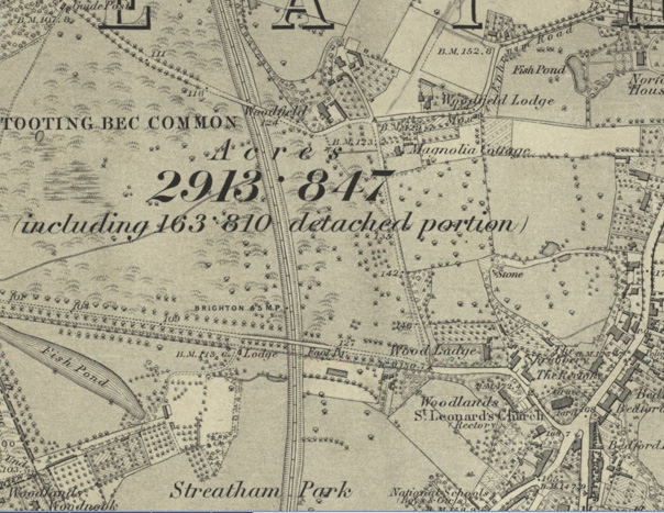
Fig. 2: 1870 OS Map. The surrounding area remains rural fields, dotted with small country houses
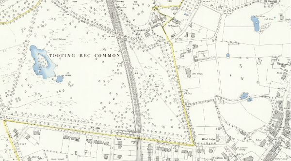
Fig. 3: 1894 OS Map. Streatham Park, to the south, has been developed for housing
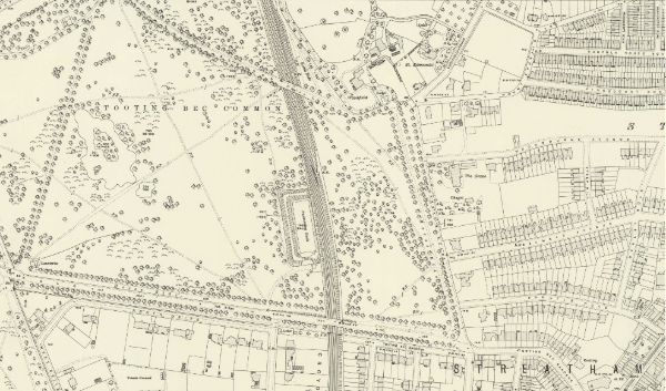
Fig. 4: 1913 OS Map. Terraced housing has begun to replace expansive private gardens. Tooting Bec Lido has been constructed.
Part 2: Conservation Area Appraisal
Location and Setting
Garrads Road Conservation Area forms the south eastern part of Tooting Bec Common, often known as Streatham Woods. It is separated from the other parts of the common by the North-south London-Brighton railway line and the accompanying metal palisade security fencing. Tooting Bec Lido is just the other side of this line.
Busy roads form clear boundaries to the north, east and south. Bedford Hill, to the north, cuts through the top of the Conservation Area which covers a small sliver of land across the other side of this road.
Landscape
Geology
Tooting Common consists primarily of Gravel and Head (weathered bedrock). This lower quality land could not be used as agriculture so was suited to its remaining use as public common land.
Topography
This part of the Common is flat with a raised lip where it meets the surrounding roads. The train line which separates it from the rest of the Common is cut through at a lower level.
Spatial Analysis
Access
The Common is freely accessible to public at no cost. It is extremely permeable to pedestrians as there are no boundary fences to separate it from the surrounding areas apart from low rails in certain areas in order to reinforce the separation between the Common and pavements.
Streets and open space, parks and gardens
Originally part of the larger Conservation Area this part of the Common is best read alongside its wider setting. The two important parts of this setting are the remainder of the Tooting Bec Common, over the railway which is a designated Common but is not a Conservation Area, and the rest of the Streatham Park and Garrads Road Conservation Area.
It is surrounded to the sides by three-lane roads with pavements. This acts as an open buffer between the Common itself and the surrounding development, giving the Common an even greater sense of openness. Much of the Common in this area can be experienced with limited views of surrounding development, emphasising its rural qualities.
The roads are detrimental to the quality of the space, separating the Common from the surrounding streets and meaning pedestrians must wait for a time to cross or find a crossing. This is particularly poor at the south-eastern corner of this section where a complicated road junction and the associated large amount of asphalt detracts from the rural qualities of the Common and the suburban quality of the development.
The Conservation Area forms an area of open green land, mostly covered in trees, between these two settings. It forms the partially wooded, open backdrop to the surrounding residential development.
Views
Long views
There are limited long views within the site due to tree cover and residential development and the lack of high ground.
Local views
There are local views through tree lined avenues within the Common, emphasising the semi-formal quality of the avenues once used as carriage drives and for horse riding.
There are local views away from the common down the streets radiating away from it such as Prentis Road and Becmead Avenue, however these views are limited.
Glimpes
Throughout the common there are glimpsed views of the surrounding buildings, often framed by the trees, creating picturesque glimpses of the early twentieth century architecture surrounding the common.
Architectural Quality and Built Form
There is little built form contained within this area. Basic street furniture such as bins, lampposts and signs are dotted amongst the trees. Two modern bus stops sit at the border. Primarily the area comprises the setting of the surrounding built form rather than containing anything of any note itself.
Surrounding area
Bordered on three sides by development, these buildings give a strong definition to the edges of the Common and dominate views out from it. There is a close historic and visual relationship between these buildings (within the Streatham Park and Garrads Road Conservation Area in Lambeth) and the Common. The former is centred on the Common and defines its western end, contributing to the suburban feel of the area.
Whilst dense terraces lead up to the Common, the area immediate to the Common remains more loosely developed with large houses set in spacious gardens which produce a consistent townscape.
This surrounding area was built up in the late Victorian and Edwardian era. Most buildings are in an Arts & Crafts style, with detailing typical of the time, emphasising vernacular architecture and quality of craftsmanship. In Garrads Road, to the east of the Common, `Mindaroo' is a Voyseyesque design with an interesting massing and long sloping roofs, gables and chimneys, and rough cast walls. The existing building of greatest age is `Saxoncroft', originally of c.1870 but much altered and extended since. The other buildings in Garrads Road were mainly built between 1900-1914 and 1935-1940, with some more recent insertions which, being set much closer to the common, fail to match the spatial and townscape qualities of earlier development. To the south, in Tooting Bec Gardens, buildings of particular note are No.38, erected in 1905 for the Bishop of Southwark; ‘Carn Brae’ of similar date and design; and, the earlier ‘Sussex House' (c.1880), on the corner of Ambleside Avenue, which is by the noted local architect Frederick Wheeler. The houses in The Spinney and 233-243 Bedford Hill, on the north side of the Common, were built by just before the Second World War.
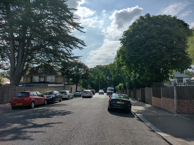
Fig. 5: Looking towards the tree cover of the common
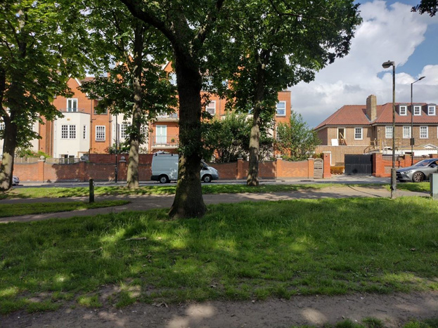
Fig. 6: Newer development is set closer to the edge of the Common than previous development
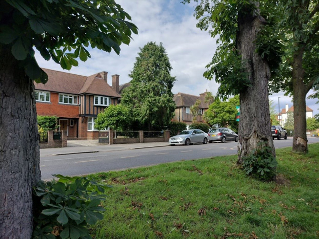
Fig. 7: Arts and Crafts housing set in their spacious grounds, viewed from the Common
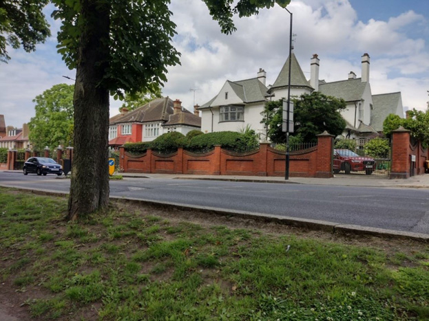
Fig. 8: Arts and Craft houses
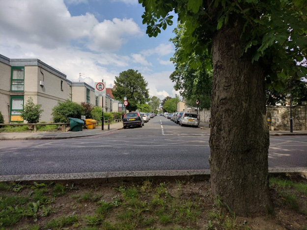
Fig. 9: Local view from the Common down Prentis Road
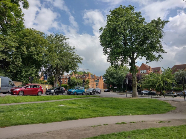
Fig. 10: The crowded road junction of Tooting Bec Road and Garrads Road.
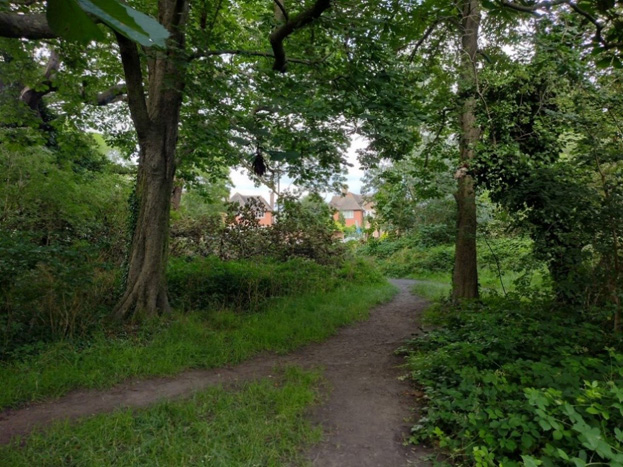
Fig. 11: A glimpsed view of the surrounding buildings from deep inside the Common
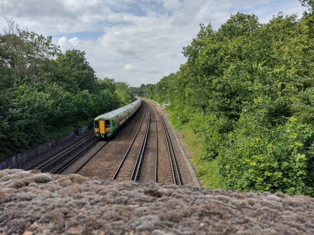
Fig. 12:The London to Brighton railway line cuts deep into the Common. In this view the Conservation Area is on the right and Tooting Bec Lido is on the left.
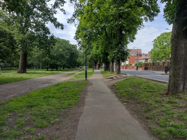
Fig. 13: The Common stepping up to meet the road, with the line of elm trees at the edge of the Common
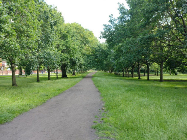
Fig. 14: The main avenue running parallel to Garrad’s Road.
Part 3: Management Strategy
Positive Features
- High quality historic Common land with a high number of old and attractive trees that evoke the rural qualities of the area’s history
- The Common land is in itself largely untouched and has not had too many formal interventions such as asphalt paths or leisure development such as playgrounds or picnic areas
- The Common retains a strong visual connection with the surrounding built development, giving attractive glimpses of these houses
- The Common retains a high quality rural, informal character despite the surrounding busy road and the railway cutting through
- Provides an attractive and open backdrop to the surrounding houses and to views looking down these roads towards the common
Threats
- Increased road usage may result in the surrounding road being more hostile to pedestrians and would increase the feeling of separation between the Common and surrounding streets
- New development adjacent to the Common may come closer to the boundary and be larger in scale, which can potentially impact upon the rural character of the Common and the townscape quality of Garrads Road
- Intensification of use of the Common land itself, which may result in piecemeal degradation and could also result in pressure to alter or develop facilities within the Common land
- Telephony masts and other equipment which would harm the rural character of the Common
- The fragmentary nature of the heritage protection of the common which is why the designating in entirety of the whole common as a conservation area should be considered
Negative Features
- New development outside the Common is closer to the Common than before and erodes part of its rural character
- Busy roads surround the Common, reducing the permeability with the surrounding residential neighbourhood. Whilst this road space acts as a useful buffer for development the noise and nature of the road traffic decreases the rural qualities of the edges of the Common
- The railway means one side of the Common has a hard edge, which decreases the number of natural routes through it
Opportunities
- Encourage new development to respect the rural and historic qualities of the Common and its existing relationship with the surrounding townscape.
- Encourage best practice and new opportunities to manage trees and paths, and to improve boundary treatments.
- New development must be fully assessed as to the potential impact on the character and appearance of the Conservation Area